File:Wien - Schweizergarten, Rudolf-Steiner-Denkmal.JPG
Jump to navigation
Jump to search


Size of this preview: 800 × 534 pixels. Other resolutions: 320 × 213 pixels | 640 × 427 pixels | 1,024 × 683 pixels | 1,280 × 854 pixels | 4,050 × 2,701 pixels.
Original file (4,050 × 2,701 pixels, file size: 9.82 MB, MIME type: image/jpeg)
Summary
| Description |
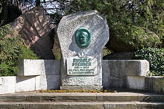
Deutsch: Das Rudolf-Steiner-Denkmal im Schweizergarten im 3. Wiener Gemeindebezirk. Die Gedenkstätte zu Ehren von Rudolf Steiner (1861–1925) wurde im Jahr 1981 nach einem Entwurf von Michael Georg und auf Initiative des Rudolf-Steiner-Gedenkstättenkomitees geschaffen, wobei das Bronzerelief die Künstlerin Elisabeth Oling-Jellinek (1915–2007) schuf: [1], File:Rudolf Steiner-IMG 7662.JPG. Nachdem das Denkmal 2014 geschändet und mutwillig beschädigt wurde, erfolgte im Jahr 2015 eine Restaurierung. Dabei wurden wegen den grassierenden Bundmetalldieben die Bronzeteile durch Kunststoffteile ersetzt, die jedoch schnell verwitterten: [2]. |
| Date | |
| Source | Own work |
| Author | C.Stadler/Bwag |
| Permission (Reusing this file) |
Deutsch: Hallo, du darfst mein Foto kostenlos nutzen, aber nenne mich bitte als Fotograf, beispielsweise „Foto: C.Stadler/Bwag“ oder © C.Stadler/Bwag; CC-BY-SA-4.0. Auf mehr Angaben bestehe ich nicht - im Gegensatz zu manch anderen, die die Vorgaben der unten angeführten Lizenzierung auf Punkt und Beistrich einfordern. English: Feel free to use my photos, but please mention me as the author like © C.Stadler/Bwag or © C.Stadler/Bwag; CC-BY-SA-4.0 (that's good enough) and if you want send me a message: bwag@gmx.net. |
| Object location | | View this and other nearby images on: OpenStreetMap |
|---|
| Camera location | | View this and other nearby images on: OpenStreetMap |
|---|
Licensing
I, the copyright holder of this work, hereby publish it under the following license:
This file is licensed under the Creative Commons Attribution-Share Alike 4.0 International license.
- You are free:
- to share – to copy, distribute and transmit the work
- to remix – to adapt the work
- Under the following conditions:
- attribution – You must give appropriate credit, provide a link to the license, and indicate if changes were made. You may do so in any reasonable manner, but not in any way that suggests the licensor endorses you or your use.
- share alike – If you remix, transform, or build upon the material, you must distribute your contributions under the same or compatible license as the original.
File history
Click on a date/time to view the file as it appeared at that time.
| Date/Time | Thumbnail | Dimensions | User | Comment | |
|---|---|---|---|---|---|
| current | 22:26, 14 April 2021 | | 4,050 × 2,701 (9.82 MB) | Bwag | {{Information |Description= {{de|1= Das Rudolf-Steiner-Denkmal im Schweizergarten im 3. Wiener Gemeindebezirk.<br/>Die Gedenkstätte zu Ehren von Rudolf Steiner (1861–1925) wurde im Jahr 1981 nach einem Entwurf von Michael Georg und auf Initiative des Rudolf-Steiner-Gedenkstättenkomitees geschaffen, wobei das Bronzerelief die Künstlerin Elisabeth Oling-Jellinek (1915–2007) schuf: [https://www.geschichtewiki.wien.gv.at/Rudolf-Steiner-Denkmal], [https://commons.wikimedia.org/wiki/File:Rudolf_St... |
File usage
The following page uses this file: