Module:Location map/data/Chile Chiloé
Jump to navigation
Jump to search
| name | Chiloé | |||
|---|---|---|---|---|
| border coordinates | ||||
| -41.758869 | ||||
| -74.908167 | ←↕→ | -72.877894 | ||
| -43.720411 | ||||
| map center | 42°44′23″S 73°53′35″W / 42.73964°S 73.8930305°W | |||
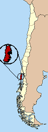
| image | Archipiélago de Chiloé-blank.PNG
| |||

| ||||

Module:Location map/data/Chile Chiloé is a location map definition used to overlay markers and labels on an equirectangular projection map of Chiloé. The markers are placed by latitude and longitude coordinates on the default map or a similar map image.
Usage
These definitions are used by the following templates when invoked with parameter "Chile Chiloé":
{{Location map|Chile Chiloé |...}}{{Location map many|Chile Chiloé |...}}{{Location map+|Chile Chiloé |...}}{{Location map~|Chile Chiloé |...}}
Map definition
name = Chiloé- Name used in the default map caption
image = Archipiélago de Chiloé-blank.PNG- The default map image, without "Image:" or "File:"
top = -41.758869- Latitude at top edge of map, in decimal degrees
bottom = -43.720411- Latitude at bottom edge of map, in decimal degrees
left = -74.908167- Longitude at left edge of map, in decimal degrees
right = -72.877894- Longitude at right edge of map, in decimal degrees
Precision
Longitude: from West to East this map definition covers 2.0303 degrees.
- At an image width of 200 pixels, that is 0.0102 degrees per pixel.
- At an image width of 1000 pixels, that is 0.002 degrees per pixel.
Latitude: from North to South this map definition covers 1.9615 degrees.
- At an image height of 200 pixels, that is 0.0098 degrees per pixel.
- At an image height of 1000 pixels, that is 0.002 degrees per pixel.
See also
Location map templates
- Template:Location map, to display one mark and label using latitude and longitude
- Template:Location map many, to display up to nine marks and labels
- Template:Location map+, to display an unlimited number of marks and labels
Creating new map definitions
return {
	name = 'Chiloé',
	top = -41.758869,
	bottom = -43.720411,
	right = -72.877894,
	left = -74.908167,
	image = 'Archipiélago de Chiloé-blank.PNG'
}