Module:Location map/data/United States Kauai
Jump to navigation
Jump to search

| This module is rated as beta, and is ready for widespread use. It is still new and should be used with some caution to ensure the results are as expected. |
| name | Kauai | |||
|---|---|---|---|---|
| border coordinates | ||||
| 22.305 | ||||
| -159.8579 | ←↕→ | -159.2352 | ||
| 21.8086 | ||||
| map center | 22°03′24″N 159°32′48″W / 22.0568°N 159.54655°W | |||
| image | Location Map Kauai.png
| |||

| ||||
| image1 | [[:File:|]]
| |||
| [[File:|400x400px]] | ||||
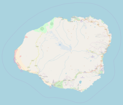
Module:Location map/data/United States Kauai is a location map definition used to overlay markers and labels on an equirectangular projection map of Kauai. The markers are placed by latitude and longitude coordinates on the default map or a similar map image.
Usage
These definitions are used by the following templates when invoked with parameter "United States Kauai":
{{Location map|United States Kauai |...}}{{Location map many|United States Kauai |...}}{{Location map+|United States Kauai |...}}{{Location map~|United States Kauai |...}}
Map definition
name = Kauai- Name used in the default map caption
image = Location Map Kauai.png- The default map image, without "Image:" or "File:"
top = 22.305- Latitude at top edge of map, in decimal degrees
bottom = 21.8086- Latitude at bottom edge of map, in decimal degrees
left = -159.8579- Longitude at left edge of map, in decimal degrees
right = -159.2352- Longitude at right edge of map, in decimal degrees
Precision
Longitude: from West to East this map definition covers 0.6227 degrees.
- At an image width of 200 pixels, that is 0.0031 degrees per pixel.
- At an image width of 1000 pixels, that is 0.0006 degrees per pixel.
Latitude: from North to South this map definition covers 0.4964 degrees.
- At an image height of 200 pixels, that is 0.0025 degrees per pixel.
- At an image height of 1000 pixels, that is 0.0005 degrees per pixel.
Examples using location map templates
Location map, using default map (image)
Hanalei Bay
Hanalei Bay (Kauai)
{{Location map | United States Kauai
 | width   = 250
 | lat_deg =  22 | lat_min = 12 | lat_sec = 52
 | lat_dir = N
 | lon_deg = 159 | lon_min = 29 | lon_sec = 52
 | lon_dir = W
 | label   = Hanalei Bay
}}
Location map many
{{Location map many | United States Kauai
 | width    = 250
 | caption  = Two locations in Kauai
 | lat1_deg =  22 | lat1_min = 12 | lat1_sec = 52
 | lat1_dir = N
 | lon1_deg = 159 | lon1_min = 29 | lon1_sec = 52
 | lon1_dir = W
 | label1   = Hanalei Bay
 | lat2_deg =  21 | lat2_min = 58 | lat2_sec = 34
 | lat2_dir = N
 | lon2_deg = 159 | lon2_min = 20 | lon2_sec = 20
 | lon2_dir = W
 | label2   = Lihue Airport
 | mark2    = Airplane silhouette.svg
 | mark2size= 10
 | position2= bottom
}}
Location map+
{{Location map+ | United States Kauai
| width   = 200
| caption = Four locations in Kauai
| places  =
  {{Location map~ | United States Kauai
   | lat_deg =  22 | lat_min = 12 | lat_sec = 52
   | lat_dir = N
   | lon_deg = 159 | lon_min = 29 | lon_sec = 52
   | lon_dir = W
   | label   = [[Hanalei Bay]]
  }}
  {{Location map~ | United States Kauai
   | lat_deg =  22 | lat_min =  5 | lat_sec = 18
   | lat_dir = N
   | lon_deg = 159 | lon_min = 20 | lon_sec = 16
   | lon_dir = W
   | label   = [[Kapaa|Kapaʻa]]
   | position= top
  }}
  {{Location map~ | United States Kauai
   | lat_deg =  22 | lat_min =  3 | lat_sec = 39
   | lat_dir = N
   | lon_deg = 159 | lon_min = 21 | lon_sec = 19
   | lon_dir = W
   | label   = [[Sleeping Giant (Kauai)|Sleeping → Giant]]
   | mark    = Red triangle with thick white border.svg
   | marksize= 16
  }}
  {{Location map~ | United States Kauai
   | lat_deg =  21 | lat_min = 58 | lat_sec = 34
   | lat_dir = N
   | lon_deg = 159 | lon_min = 20 | lon_sec = 20
   | lon_dir = W
   | label   = ↑<br/>[[Lihue Airport]]
   | mark    = Airplane silhouette.svg
   | marksize= 10
   | position= bottom
  }}
}}
See also
Location map templates
- Template:Location map, to display one mark and label using latitude and longitude
- Template:Location map many, to display up to nine marks and labels
- Template:Location map+, to display an unlimited number of marks and labels
Creating new map definitions
return {
	name = 'Kauai',
	image = 'Location Map Kauai.png',
	image1 = '',
	top = 22.3050,
	bottom = 21.8086,
	left = -159.8579,
	right = -159.2352
	}